What people mean by “super El Niño”
Forecasters classify El Niño–Southern Oscillation (ENSO) warmth using Pacific sea-surface benchmarks—especially Niño3.4, a central-eastern tropical strip whose anomalies track how energy piles into the ocean–atmosphere system. Once anomalies persist near +0.5°C, an El Niño is underway; beyond roughly +1.5°C, language shifts to strong events; beyond +2°C, many specialists apply the informal “super El Niño” label—only a handful have cleared that bar since mid-century instrumental coverage matured.
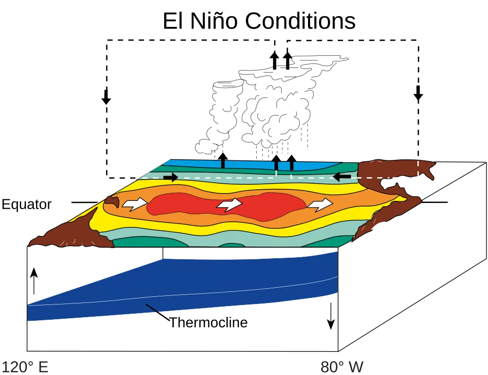
The coupled machinery that briefly heats the planet faster
During El Niño, the Walker circulation—the east–west atmospheric loop that normally piles warm water and towering thunderstorms toward the western Pacific—weakens. Indonesia–scale convection slackens while Peru–adjacent waters warm. With fewer bright tropical clouds reflecting sunlight back to space, and with altered evaporation and upper-air wave trains, Earth’s energy budget tilts toward net absorption at the same time human-emitted greenhouse gases already enforce a persistent surplus.
That coupling is why ENSO does not merely shuffle regional inconvenience—it elevates global mean surface temperature (GMST) anomalies above what trendlines alone would predict for a given year.
Why “record-breaking warming” enters the conversation now
Independent quarterly analyses compiled by researchers including Carbon Brief merge multiple observational groups (NASA GISTEMP, NOAA, HadCRUT, Berkeley Earth, ERA5) to bracket annual outcomes. Their April 2026 assessment noted January–March ranked among the hottest starts on record despite fading La Niña chill early in the year—already proof that human forcing dominates even before Pacific warmth peaks.
Looking ahead, ensemble summaries drawn from 637 initialized model trajectories across 13 modeling centers pointed—at publication—to a median Niño3.4 anomaly near +2.2°C by September, squarely inside super El Niño territory in many frameworks. Peak ENSO warmth historically arrives later still (November–January window), meaning September snapshots understate where extremes might finish.
Probabilities: stacked decks but not certainty
Combining early-year observations with projected ENSO evolution, the same synthesis estimated 2026 global warmth near 1.47°C above pre-industrial baselines (within roughly 1.37–1.58°C uncertainty), making second-place annual rankings likely while leaving roughly one-in-five odds of overtaking prior annual highs—conditional on how quickly Pacific warmth couples into tropospheric readings.
The lag your headline warns about
GMST typically lags peak tropical Pacific forcing by months: thermal inertia in ocean mixed layers, reorganized jet streams, and delayed soil-moisture feedbacks mean thermometers worldwide crest after ENSO indices max—historically explaining why standout calendar years often align with post-peak intervals (1998, 2016, 2024 patterns cited in climate-state reporting). If a super El Niño crests late 2026, much of the headline warmth may spill visibly into 2027, even as Pacific anomalies ease.
Beyond thermometers, humanitarian impacts inherit longer memories: drought seeds stressed hydrology that persists seasons downstream; wildfire fuels accumulate after rain deficits; crop logistics stagger across hemispheres; coral bleaching budgets take years to amortize. Those systems react on timelines disconnected from weekly ENSO bulletins.
Why spring forecasts still deserve humility
NOAA communicators emphasize the spring predictability barrier—March–May stretches when ocean–atmosphere coupling remains noisy—so aggressive expectations before summer can overshoot. Models disagree: some ensembles still simulate only moderate warmth by autumn. Until coupling locks in, treat multimodel medians as risk diagnostics, not prophecy.
What satellites already showed before peak ENSO
Quarterly synthesis reporting comparing multiple datasets flagged 2026’s opening quarter among the hottest Jan–Mar stretches ever measured despite weak La Niña residue early on—evidence that planetary heating from greenhouse gases now overwhelms typical cool-phase damping within months. ERA5 gridded diagnostics summarized in those assessments showed roughly 5.2% of Earth’s surface registering record warmth for the quarter while essentially nowhere landed record cold—an extreme asymmetry consistent with long-tail warming rather than benign variability.
Ocean heat does not vanish when winds flip
Even after El Niño relaxes, subsurface heat accumulated across the Pacific can redistribute through Kelvin waves, sustaining marine heatwaves, accelerating ice-sheet-adjacent melt risk, and elevating hurricane fuel later in calendar years. That reservoir explains why fisheries managers, reinsurers, and disaster planners track ENSO seasons as multi-year balance-sheet shocks—not mere quarterly anomalies.
Bottom line
A super El Niño matters because it stacks natural variability atop decades of anthropogenic warming, bending annual charts toward records while rearranging rainfall and wildfire risk continents away from the Pacific. And it matters because El Niño’s echo—in lagged heat records and slower ecological wounds—can outlive the flashy sea-surface peak politicians quote on cable news.